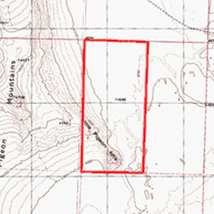
- Location: Western Box Elder County, in Northwest Utah, approximately 40 miles north of I-80 at Wendover, Utah; 12 miles east of the Pilot Mountain Range. The southern portion of this parcel is on Little Pigeon Mountain.
- Access: From Utah Highway 30, about 9 miles east of the Nevada state line, turn south on Grouse Creek Road (this becomes Pilot Mountain Road south of Lucin). Go approximately seven miles to a road to the east (Pigeon Mountain Road). Go about nine miles, just past Little Pigeon Mountain. The property is just south of the road. Although the property is just off the road, there is no legal access.
- Topography: The property is fairly flat, except the southwest corner, which rises up and includes a portion of Little Pigeon Mountain – see topographical map.
- Soil: The soil is a silt loam except on the mountain, which includes rock outcroppings.
- Vegetation: Sagebrush and other vegetation typical of high desert.
- Water: There are no wells on the property.
- Views: Distant views of the Pilot Mountain Range to the west and the Grouse Creek Mountains to the north.
- Elevation: Varies from 4,280 feet to about 4,500 feet on the mountain.
- Wildlife: Jack rabbits, coyotes, antelope throughout the area, with elk and mountain lions in the distant mountain ranges.
- Area: This area is very sparsely populated. There are no improvements within sight of this property. Wendover is about a 50 mile drive from the property. West Wendover, Nevada, on the Utah State line at I-80, is a popular entertainment and gambling destination. Most of the nearby mountains are owned by the U.S. Bureau of Land Management, and are open to public hunting and recreation.
- Zoning: MU-160. 160 or more acres are required to obtain a building permit. This zoning is intended to maintain open space.
- Taxes: $20.78 in 2011.
- Utilities: None.
- Uses: Investment. Cattle grazing. Recreation. There is access to many miles of roads and trails from this property, making it ideal for ATV riding, horseback riding, hiking, camping, etc. Elk are found in the Pilot Mountains, as well as coyotes and mountain lions. This is a very remote area. The nearby road dead ends a few miles to the east.
- Terms: Owner financing is available for $2,000 down, 6% interest, $337 per month payments over 20 years. 10% discount for cash. Exchange offers considered.
- Legal: West ½, Section 1, Township 6 North, Range 17 West, Salt Lake Base and Meridian.
- Price: $56,000, $175 per acre
- Acres: 320
GPS Coordinates
Northwest corner: 41 degrees, 16.663’ North latitude. 113 degrees, 45.193 West longitude.
Northeast corner: 41 degrees, 16.658’ North latitude. 113 degrees, 44.626’ West longitude.
Southeast corner: 41 degrees, 15.709’ North latitude. 113 degrees, 44.649’ West longitude.
Southwest corner: 41 degrees, 15.716’ North latitude. 113 degrees, 45.215’ West longitude.

