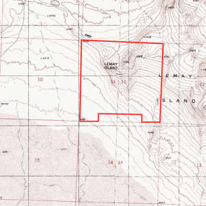
560 Acres – $98,000
 To access interactive topographic mapping click here. |
View larger interactive map |
- Location: Western Box Elder County, in Northwest Utah, approximately 35 miles north of I-80 at Wendover, Utah; about 2 miles east of Pilot Mountain Road, and 5 miles east of the Pilot Mountain Range.
- Access: From Interstate 80 near the Utah/Nevada state line, take exit 4 and go north. The road is paved for the first several miles, then becomes gravel. At approximately 35 miles from I-80, the road rises up a hill and proceeds north from the salt flats. About ½ mile north of the summit of this hill, and across from a sign that reads “Patterson Pass,” take a two-track road to the right (east). Lemay Island Mountain will be in front of you. Proceed two plus miles to the summit of the mountain. This is approximately the center of the property.
- Topography: The property varies from gently rolling in the southwest corner, to very steep near the summit in the center of the property – see topographical map.
- Soil: The soil is gravelly in most places, with finer soil on the lower elevations to the south. There are rocky outcroppings at the higher elevations.
- Vegetation: Sagebrush and other vegetation typical of high desert.
- Water: There are no wells on the property, but there are water wells on property approximately three miles north and west of the property.
- Views: Spectacular views of the Pilot Mountain Range to the west, and views of the salt flats to the south and the Silver Island Mountains beyond. As this property includes a mountain top, there are elevated 360 degree views of the surrounding country.
- Elevation: Varies from about 4,250 feet to about 4,800 feet.
- Wildlife: Jack rabbits, coyotes, antelope throughout the area, with elk and mountain lions in the Pilot Mountains.
- Area: This area is very sparsely populated, with only an occasional ranch headquarters or homestead. Between the property and Wendover 35 miles to the south are one ranch headquarters and one other home. West Wendover, Nevada, on the Utah State line at I-80, is a popular entertainment and gambling destination. Most of the nearby mountains are owned by the U.S. Bureau of Land Management, and are open to public hunting and recreation. Every other section in this area is government owned and available for public use, subject to BLM restrictions.
- Zoning: MU-160. 160 or more acres are required to obtain a building permit. This zoning is intended to maintain open space.
- Taxes: $128.76 in 2011.
- Utilities: None
- Uses: Investment. Headquarters for recreational activities, or off-the-grid homestead. Although mountainous, most of the property can be driven by four-wheel vehicles, making it ideal for ATV riding, horseback riding, hiking, camping, etc. There is a road directly across from this property into and through the nearby Pilot Mountains via Patterson Pass. Elk are found in the Pilot Mountains, as well as coyotes and mountain lions. This is a spectacular recreation area!
- Terms: Owner financing is available for $3,000 down, 6% interest, $681 per month payments over 20 years. 10% discount for cash. Exchange offers considered.
- Legal: The North Half, the North Half of the South Half, the Southwest Quarter of the Southwest Quarter, the Southeast Quarter of the Southeast Quarter of Section 11, Township 5 North, Range 18 West, Salt Lake Base and Meridian.
- Price: $98,000, $175 per acre
- Acres: 560
Northeast corner: 41 degrees, 10.349’ North latitude. 113 degrees, 51.940’ West longitude.
Southeast corner: 41 degrees, 09.488’ North latitude. 113 degrees, 51.938’ West longitude.
Southwest corner: 41 degrees, 09.477’ North latitude. 113 degrees, 53.087’ West longitude.
Northwest corner: 41 degrees, 10.348 ‘ North latitude. 113 degrees, 53.093’ West longitude.
Corner #10: 41 degrees, 09.477’ North latitude. 113 degrees, 52.800’ West longitude.
Corner #9: 41 degrees, 09.694’ North latitude. 113 degrees, 52.801’ West longitude.
Corner #6: 41 degrees, 09.702’ North latitude. 113 degrees, 52.226’ West longitude.
Corner #5: 41 degrees, 09.487’ North latitude. 113 degrees, 52.225’ West longitude.
