160 Acres – $40,000 – SOLD
 To access interactive topographic mapping click here. |
View larger interactive map |
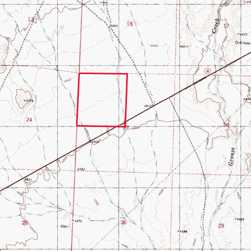
- Location: Western Box Elder County, Northwest Utah, approximately 50 miles north of I-80 at Wendover, Utah; and four miles east of the Nevada/Utah state line on the north side of Highway 30.
- Access: From Interstate 80, 32 miles west of the Utah/Nevada state line, go northeast on Highway 233 to the Utah State line, where it becomes Highway 30. Go about four miles to the property on the north side of Highway 30.
- Topography: The property is gently rolling.
- Soil: The soil is a silty loam.
- Vegetation: Sagebrush and other vegetation typical of high desert.
- Water: None on property. Water rights would have to be applied for with the Utah Division of Water Rights.
- Elevation: About 4,600 feet.
- Wildlife: Jack rabbits, coyotes, antelope throughout the area, with elk and mountain lions in the nearby Pilot Mountains.
- Area: This area is sparsely populated, with no homes or buildings in site of this property. West Wendover, Nevada, on the Utah State line at I-80, is about 50 miles south of this property, and is a popular entertainment and gambling destination. Montello, Nevada is about 15 miles west of the property. Most of the nearby mountains are owned by the U.S. Bureau of Land Management (BLM), and are open to public hunting and recreation.
- Zoning: That portion of the property north of Highway 30 is not zoned.
- Taxes: $37.46 in 2011.
- Utilities: None available.
- Uses: Investment. Ranch. Homestead. Note that this property has highway frontage.
- Terms: Owner financing terms: $2,000 down, 6% interest, $236 per month over 20 years. 10% cash discount.
- Legal: The Northwest ¼ of Sec. 19, Township 8 North, Range 18 West, Salt Lake Base and Meridian, Box Elder County, Utah.
- Price: $32,000, $200 per acre
- Acres: 160
GPS Coordinates
NE corner: 41 degrees, 24.381’ N latitude. 113 degrees, 57.240’ W longitude.
SE corner: 41 degrees, 23.933’ N latitude. 113 degrees, 57.241’ W longitude.
