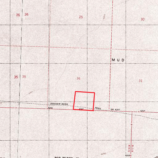
- Location: Western Box Elder County, in Northwest Utah, approximately 20 miles north of I-80 at Wendover, Utah; between the Silver Island Mountains and the Pilot Mountain Range.
- Access: From Interstate 80 near the Utah/Nevada state line, take exit 4 and go north. Go five miles to the Silver Island Mountain Loop Road to the right. Go about 18 miles to the Donner Reed Trail to the west. Go about three miles to the property. The trail passes through the south portion of the property. Note that this trail is poorly marked and is not passable part of the year.
- Topography: The property is flat.
- Soil: The soil is a silty clay.
- Vegetation: Very little – mostly barren.
- Water: There are no wells on the property.
- Views: Spectacular views of the Pilot Mountain Range to the west, and the Silver Island Mountains to the east.
- Elevation: About 4,240 feet.
- Wildlife: Jack rabbits, coyotes, antelope, elk and mountain lions in the Pilot Mountains.
- Area: This area is very sparsely populated. West Wendover, Nevada, about 20 miles south on the Utah State line at I-80, is a popular entertainment and gambling destination. Most of the nearby mountains are owned by the U.S. Bureau of Land Management, and are open to public hunting and recreation. Every other section in this area is government owned and available for public use, subject to BLM restrictions.
- Zoning: MU-160. 160 or more acres are required to obtain a building permit. This zoning is intended to maintain open space.
- Taxes: $9.36 in 2011.
- Utilities: None
- Uses: Investment. Recreation. A piece of history, as this property is part of the historic Donner Reed Trail, across which the ill-fated Donner Reed party passed on their way to California in 1846. 87 pioneers crossed this trail, but only 46 survived to make it to California the following spring.
- Terms: $1,000 down, $50/month for 6 years. 6% interest rate. Exchange offers considered.
- Legal: Southwest ¼ of the Southeast ¼ of Section 36, Township 4 North, Range 18 West, Salt Lake Base and Meridian.
- Price: $4,000, $100 per acre
- Acres: 40
GPS Coordinates
Northeast corner: 41 degrees, 00.929’ North latitude. 113 degrees, 51.171’ West longitude.
Southeast corner: 41 degrees, 00.712’ North latitude. 113 degrees, 51.171’ West longitude.
Southwest corner: 41 degrees, 00.712’ North latitude. 113 degrees, 51.458’ West longitude.
Northwest corner: 41 degrees, 00.929 ‘ North latitude. 113 degrees, 51.458’ West longitude.

